Hyderabad Metro Map, the thriving metropolis nestled in the heart of South India, pulsates with life, culture, and commerce. However, its burgeoning population and the resulting traffic congestion have long been a cause for concern among its residents. In this urban sprawl, the Hyderabad Metro emerges as a beacon of hope, a modern marvel that not only eases the daily commute but also signifies progress and development.
In this blog post, we embark on a journey to uncover the intricacies of the Hyderabad Metro Map, unraveling the lifelines that connect neighborhoods, businesses, and dreams. Join us as we delve deep into this transportation network, exploring its routes, stations, and the remarkable impact it has on the city’s landscape. Hyderabad’s Metro Map holds the key to smoother, more efficient, and eco-friendly travel – let’s navigate its secrets together.
1.Hyderabad Metro Map: The Genesis of Hyderabad Metro
• Discuss the historical background and need for a metro system.
The historical background of Hyderabad metro system dates back to the early 2000s when the city’s rapid urbanization led to severe traffic congestion and pollution. Recognizing the need for a sustainable and efficient transportation solution, the government initiated the metro project. Its aim was to provide a modern, reliable, and eco-friendly mode of transit for the growing population.
• Mention key milestones and decisions leading to its construction.
The construction of Hyderabad metro map system was marked by several key milestones and crucial decisions. In 2008, the government approved the Hyderabad Metro Rail project. It involved significant decisions such as selecting the Public-Private Partnership (PPP) model for development. Larsen & Toubro and the Andhra Pradesh government entered into a partnership for construction. The foundation stone was laid in 2012, and by 2017, the first phase became operational, connecting Miyapur and Nagole. These milestones represented a remarkable journey from planning to execution, transforming the city’s transportation landscape.
• Highlight the significance of the Hyderabad
Metro in urban development.
The Hyderabad Metro holds immense significance for the city and its residents:
1.Traffic Decongestion: Hyderabad’s ever-growing population and vehicular traffic had led to gridlock on its roads. The metro system significantly reduces road congestion, making daily commutes faster and more efficient.
2.Environmentally Friendly: By encouraging the use of public transportation, the metro contributes to reducing air pollution and carbon emissions, promoting a cleaner and greener environment.
3.Economic Growth: Improved connectivity via the metro boosts economic activities by facilitating the movement of people and goods. It encourages commercial development around metro stations.
4.Ease of Commuting: The metro is a lifeline for daily commuters, providing a comfortable and reliable mode of transport that saves time and money.
5.Accessibility: The metro is inclusive, with provisions for differently-abled passengers, making it accessible to all segments of society.
6.Tourism: Tourists benefit from easy access to major attractions and historical sites, enhancing the city’s tourism sector.
7.Modern Infrastructure: The metro is a symbol of modernization, showcasing Hyderabad’s commitment to progress and urban development.
In essence, the Hyderabad Metro map is not just a transportation system; it’s a catalyst for growth, sustainability, and improved quality of life for the city and its people.
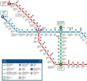
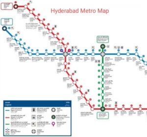
2. Hyderabad Metro Map : Hyderabad Metro Routes
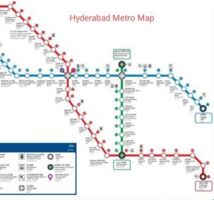
• Provide an overview of the three metro lines (Red, Green, and Blue).
Hyderabad metro system boasts three primary lines, each contributing to the city’s connectivity and accessibility:
1.Red Line: Spanning approximately 29 kilometers, the Red Line connects the northern suburb of Miyapur to the southern neighborhood of LB Nagar. It traverses densely populated areas, serving commuters, residential zones, and major commercial hubs.
2.Green Line: Stretching across about 15 kilometers, the Green Line provides vital east-west connectivity. It links the historic JBS (Jubilee Bus Station) to Falaknuma, connecting heritage sites, bustling markets, and residential neighborhoods.
3.Blue Line: Extending over 28 kilometers, the Blue 3.Line plays a crucial role in connecting the IT and business hubs of Hi-Tech City to the eastern suburb of Nagole. This line supports the booming tech sector and offers commuters efficient access to these vital areas.
Together, these metro lines form a comprehensive network that enhances mobility and accessibility across Hyderabad, reducing travel time and traffic congestion.
• Explain their connectivity and major stations on each line.
The connectivity and major stations on each of Hyderabad’s metro lines:
1. Red Line:
•The Red Line runs from Miyapur in the northwest to LB Nagar in the southeast.
• It intersects with both the Green and Blue Lines, enhancing overall connectivity.
• Major stations include: Miyapur, JNTU College, KPHB Colony, Kukatpally, Balanagar, Moosapet, Bharat Nagar, Erragadda, ESI Hospital, SR Nagar, Ameerpet, Punjagutta, Khairatabad, Lakdikapul, Assembly, Nampally, Gandhi Bhavan, Osmania Medical College, MG Bus Station (MGBS), Malakpet, New Market, Mus Arambagh, Dilsukhnagar, Chaitanyapuri, Victoria Memorial, L.B. Nagar.
2. Green Line:
• The Green Line spans from JBS (Jubilee Bus Station) in the west to Falaknuma in the southeast.
• It intersects with the Red Line, providing essential east-west connectivity.
• Major stations include: JBS, Parade Grounds, Secunderabad, Gandhi Hospital, Musheerabad, RTC Cross Roads, Chikkadpally, Narayanguda, Sultan Bazar, Salar Jung Museum, Charminar, Shalibanda, Shamsher Gunj, Jangam Met, Falaknuma.
3. Blue Line:
• The Blue Line extends from Nagole in the east to Hi-Tech City in the west.
• It intersects with the Red Line, facilitating east-west connectivity and serving as a lifeline for the IT sector.
• Major stations include: Nagole, Uppal, Survey of India, NGRI, Habsiguda, Tarnaka, Mettuguda, Secunderabad, Parade Grounds, Paradise, Rasoolpura, Prakash Nagar, Begumpet, Ameerpet, Madhura Nagar, Yousufguda, Jubilee Hills Check Post, Peddamma Temple, Madhapur, Durgam Cheruvu, HITEC City.
These major stations serve as essential transit points and are strategically located to connect residential areas, commercial districts, and cultural landmarks, making Hyderabad’s metro system a vital part of the city’s transportation infrastructure.
• Mention any future expansions or proposed lines.
Hyderabad’s metro system continues to expand with ambitious future plans, including the proposed extension of existing lines and the addition of new ones. Notable expansions include the extension of the Red Line from LB Nagar to Hayathnagar and the planned Red Line extension to the Shamshabad International Airport, enhancing connectivity further. Additionally, the development of the Purple Line, connecting BHEL to LB Nagar, is in the pipeline, aiming to provide even more comprehensive metro coverage.
3.Hyderabad Metro Map : Red Line – North to South Journey
• Explore the Red Line’s route from Miyapur to LB Nagar.
The Red Line of Hyderabad’s metro spans approximately 29 kilometers, offering seamless connectivity from Miyapur in the northwest to LB Nagar in the southeast. Along its route, it serves densely populated areas, major commercial districts, and key residential zones. Notable stations include Ameerpet, Punjagutta, Nampally, and Dilsukhnagar. The Red Line’s extensive coverage plays a pivotal role in easing daily commutes and improving accessibility across the city.
• Discuss key stations and landmarks along the way.
The Red Line of Hyderabad Metro map asses through several key stations and landmarks, enhancing 1.urban connectivity:
•Ameerpet: A bustling commercial and educational hub.
•Punjagutta: Home to renowned hospitals and shopping centers.
•Nampally: Close to Hyderabad Deccan Railway Station and Exhibition Grounds.
•Dilsukhnagar: A major residential and commercial area.
These stations not only facilitate daily commuting but also provide access to prominent institutions, healthcare facilities, and shopping destinations.
• Mention how the Red Line connects major residential and commercial areas.
The Red Line of Hyderabad Metro map serves as a vital link connecting major residential and commercial areas.
• Residential Areas: It passes through densely populated neighborhoods like Miyapur, Kukatpally, and Dilsukhnagar, providing residents with a convenient and efficient mode of transportation for their daily commutes.
• Commercial Hubs: Key commercial districts such as Punjagutta and Ameerpet are accessible via the Red Line, facilitating easy access for employees and shoppers.
By connecting these areas, the Red Line significantly enhances urban mobility and contributes to the city’s economic development.
4.Hyderabad Metro Map : Green Line – East to West Connectivity
• Discuss the Green Line’s route from JBS to Falaknuma.
The Green Line of Hyderabad Metro stretches approximately 15 kilometers, connecting JBS (Jubilee Bus Station) in the west to Falaknuma in the southeast. Along its route, it serves historic and culturally rich areas, including Charminar, making it an essential transport artery connecting the city’s heritage with modern urban life.
• Highlight important stations and attractions.
The Green Line of Hyderabad Metro boasts significant stations and attractions:
• Charminar: An iconic monument, emblematic of Hyderabad’s heritage.
• Salar Jung Museum: Home to a vast collection of art and artifacts.
• Parade Grounds: A historical venue for events and exhibitions.
• Secunderabad: A bustling twin city with its railway station.
• JBS (Jubilee Bus Station): A major intercity bus terminal.
• Falaknuma: Known for the opulent Falaknuma Palace, a historical treasure.
These stations connect culture, history, and modern life, making the Green Line a unique metro experience.
• Emphasize the role of the Green Line in connecting historical sites.
The Green Line of Hyderabad Metro plays a pivotal role in connecting the city’s rich historical sites, serving as a time-traveling conduit through the past. Notably, it links Charminar, a globally recognized symbol of Hyderabad’s history, with the Salar Jung Museum, housing an astounding collection of artifacts from diverse cultures. This connectivity allows residents and tourists alike to seamlessly explore and appreciate Hyderabad’s vibrant heritage, making the Green Line a cherished cultural link in the city’s urban fabric.
5. Hyderabad Metro Map:Blue Line – Linking Hi-Tech City
• Describe the Blue Line’s route from Nagole to Raidurg.
The Blue Line of Hyderabad Metro map covers a route of approximately 28 kilometers, connecting Nagole in the east to Raidurg in the west. Along its journey, it traverses several key areas, including major IT and business districts. This route plays a crucial role in facilitating efficient commuting for professionals while linking residential neighborhoods to these economic hubs, making it a vital lifeline for the city’s workforce and residents.
• Mention prominent stations and their significance.
The Blue Line of Hyderabad Metro includes prominent stations with significant importance:
Nagole: The eastern terminus, serving as a major residential area.
Hitec City: An epicenter of Hyderabad’s IT industry, housing numerous tech companies.
Madhapur: Another IT and commercial hub with shopping and dining options.
Jubilee Hills Check Post: An upscale residential and shopping district.
Durgam Cheruvu: Near the serene Durgam Cheruvu Lake, offering a tranquil escape.
HITEC City: The heart of Hyderabad’s tech industry, hosting numerous tech parks.
Raidurg: The western terminus, near financial and business districts.
These stations cater to a diverse range of needs, from work to leisure, reflecting the dynamic nature of the Blue Line’s route.
• Explain how the Blue Line aids the IT and business sectors.
The Blue Line of Hyderabad Metro map plays a pivotal role in aiding the IT and business sectors in the city:
Connectivity: It directly connects IT professionals from residential areas to major IT parks and offices in HITEC City and Madhapur. This reduces commute times and enhances productivity.
Traffic Reduction: By providing an efficient alternative to private vehicles, the Blue Line helps reduce traffic congestion around IT hubs, improving overall mobility.
Accessibility: It ensures easy access for employees to their workplaces, making it an attractive choice for both businesses and professionals.
Economic Impact: The Blue Line’s role in connecting IT and business districts fosters economic growth by facilitating the movement of a skilled workforce and supporting business activities.
Overall, the Blue Line significantly contributes to the success and sustainability of Hyderabad’s thriving IT and business sectors.
6.Hyderabad Metro Map: Ticketing and Fare Information
• Explain the ticketing system (smart cards, tokens, and mobile apps).
Hyderabad Metro offers a convenient ticketing system that caters to diverse passenger preferences:
Smart Cards: These reusable contactless cards are available in various denominations. Commuters can load them with a specific amount and tap them at the entry and exit gates. Smart cards offer the benefit of saving time and money for frequent travelers.
Tokens: Single-journey tokens are available for one-time use. Passengers purchase these tokens at ticket counters or vending machines and use them to enter the metro station. Tokens are suitable for occasional travelers.
Mobile Apps: Hyderabad Metro map also provides a mobile app for purchasing tickets digitally. Passengers can buy and store tickets on their smartphones, using QR codes for entry. This option is popular among tech-savvy commuters.
These ticketing options cater to the diverse needs of passengers, ensuring a hassle-free and efficient metro travel experience.
• Provide fare details and any discounts available. Hyderabad Metro had a fare structure based on the distance traveled. Keep in mind that fare details may have changed, so it’s advisable to check the official Hyderabad Metro website or contact them for the most up-to-date information.
Here’s a general idea of the fare structure:
• Minimum Fare: The minimum fare typically covers a short distance, starting from around Rs. 10-20 for the shortest trips.
• Fare Bands: Fares increase with the distance traveled, with various fare bands reflecting the distance between stations.
• Discounts: Hyderabad Metro map may offer discounts for specific groups such as students, senior citizens, and differently-abled passengers. These discounts are subject to eligibility and may require valid identification.
For the latest fare details and available discounts, please visit the official Hyderabad Metro website or contact their customer service for accurate and current information.
• Share tips for cost-effective commuting.
To ensure cost-effective commuting on Hyderabad Metro:
• Use a smart card for discounted fares on regular trips.
• Plan your journeys during off-peak hours when fares might be lower.
• Explore monthly or quarterly pass options for further savings if you’re a regular commuter.
• Check for any ongoing promotions or discounts.
7.Hyderabad Metro Map: Metro Timings and Frequency .
• Discuss the operational hours and frequency of trains.
Hyderabad Metro map typically operates from 6:00 AM to 10:00 PM. Trains run at intervals of approximately 5-10 minutes during peak hours and 15-20 minutes during off-peak times. Please verify the current operational hours and train frequency on the official Hyderabad Metro website, as they may have changed since then.
• Mention peak and off-peak hours for commuters.
During typical operating hours, peak and off-peak hours for Hyderabad Metro commuters are as follows:
1. Peak Hours:
•Morning peak hours: 8:00 AM to 10:00 AM.
•Evening peak hours: 5:00 PM to 8:00 PM.
2.Off-Peak Hours:
Outside of the aforementioned peak hours, which are generally less crowded and may offer lower fares. However, it’s advisable to check with Hyderabad Metro for the most current information on peak and off-peak hours as they may vary.
• Explain any updates or changes in timing.
Therefore, I can’t provide specific information about any updates or changes in Hyderabad Metro’s timings that may have occurred since then. For the most accurate and up-to-date information regarding operational hours and any recent changes, I recommend visiting the official Hyderabad Metro website or contacting their customer service directly.
8. Hyderabad Metro Map : Traveling Comfortably and Safely
1. Share tips on how to have a comfortable metro ride.
• Plan Ahead: Check the metro schedule and timings to avoid waiting unnecessarily.
• Arrive Early: Arrive at the station a little early to find a good spot on the platform.
• Use Smart Cards: Smart cards save time and are more convenient than tokens.
• Stand Clear: Allow passengers to exit before boarding, and move away from doors to make space.
• Offer Seats: Be considerate and offer your seat to those in need, like seniors or pregnant passengers.
• Keep Noise Down: Use headphones for music and keep conversations at a reasonable volume.
• Keep Personal Space: Respect personal space and avoid crowding others.
• Secure Belongings: Keep your belongings secure to prevent inconvenience to yourself and others.
• Follow Rules: Abide by all safety and security regulations, including wearing masks if required.
• Stay Informed: Be aware of station announcements and stops to avoid missing your destination.
By following these tips, you can make your metro ride more enjoyable for yourself and fellow passengers.
• Discuss safety measures in place for passengers.
Hyderabad Metro map prioritizes passenger safety with various measures:
CCTV Surveillance: Stations and trains are equipped with cameras for security.
Emergency Buttons: Passengers can use these to alert authorities in case of issues.
Security Personnel: Staff and security personnel are present to assist passengers.
Fire Safety: Metro coaches are equipped with fire safety measures.
COVID-19 Protocols: During the pandemic, hygiene and social distancing measures were enforced.
Evacuation Plans: In case of emergencies, clear evacuation plans are in place.
9.Hyderabad Metro Map : Exploring Hyderabad via Metro
• Suggest tourist attractions and landmarks accessible by metro.
Hyderabad Metro provides easy access to several tourist attractions and landmarks, including Charminar, Salar Jung Museum, Birla Mandir, Hussain Sagar Lake, and the historic Chowmahalla Palace. These destinations offer a glimpse into the city’s rich heritage and culture.
• Emphasize the convenience of metro travel for tourists.
Metro travel in Hyderabad offers tourists convenience by connecting major attractions, saving time, and reducing the hassle of navigating traffic. It’s a cost-effective and efficient way to explore the city’s cultural and historical treasures.
• Encourage readers to plan their city exploration using the metro.
I encourage readers to plan their city exploration using the metro. With its convenience, affordability, and accessibility to key attractions, Hyderabad Metro is the ideal way to embark on a seamless and memorable journey through the city’s vibrant culture and heritage. Unlock the treasures of Hyderabad, one metro ride at a time!
10.Future Developments:
Hyderabad Metro continues to expand with several upcoming projects. These include extensions of existing lines, such as the Red Line’s proposed connection to Shamshabad International Airport and the Purple Line from BHEL to LB Nagar. These expansions will further enhance the metro’s reach and accessibility.
11. Positive Impact on City’s Growth:
The Hyderabad Metro map has been a catalyst for economic growth, decongesting traffic, reducing pollution, and improving urban mobility. It has boosted connectivity to key areas, attracting investments, and making Hyderabad a more livable and vibrant city.
Conclusion:
The Hyderabad Metro Map is not just a navigational tool; it’s a symbol of progress, connectivity, and sustainability. For residents, it’s a lifeline for daily commutes, while for visitors, it’s a gateway to exploring the city’s rich heritage. Its significance lies not just in its routes and stations but in its role in shaping Hyderabad’s future as a dynamic and forward-looking metropolis.
FAQs:
1.Hyderabad Metro map hd
2.Metro Map Hyderabad PDF
3.Hyderabad Metro timings
4.Hyderabad Metro stations list
5.Hyderabad Metro app
6.Hyderabad Metro fare